The Power of Public Data: Brazilian Open Data Portal
Balancing and addressing both computational capacity as well as the maintenance of farmer data ownership are critical as we think about the usability of all this data.
As our platform expands around the world, we’re in a unique position in 2021 not only to drive availability of digital tools for all kinds of farmers, but to build out our data layers across the world and make the Climate FieldView™ platform even more robust for all our customers.

As our platform expands around the world, we’re in a unique position in 2021 not only to drive availability of digital tools for all kinds of farmers, but to build out our data layers across the world and make the Climate FieldView™ platform even more robust for all our customers.
Our digital farming opportunity depends simultaneously on the data farmers manage within FieldView™, as well as relevant, publicly available, historical and regional reference data we have on hand. When customers are in the driver’s seat, combining the data from their operation that they own and control with these reference data layers is what makes our platform so powerful, and allows us to offer agronomic solutions at the individual field level.
In November 2020, our teams partnered across Climate LLC, Bayer Crop Science, and the team at InnoCentive to put together a public challenge that directly addresses data opportunities in Europe and South Africa, where we have yet to incorporate some of the critical data layers for which we have more historical information in the United States.
This process by which we opened ourselves up to the ingenuity of the public was exciting and new. This ideation challenge was the first of its kind offered by Bayer and Climate, with a simple-sounding premise: to provide information on georeferenced soil databases and elevation models — not the data itself, but instead information on potential sources of such — for our teams to evaluate and assess for future use.

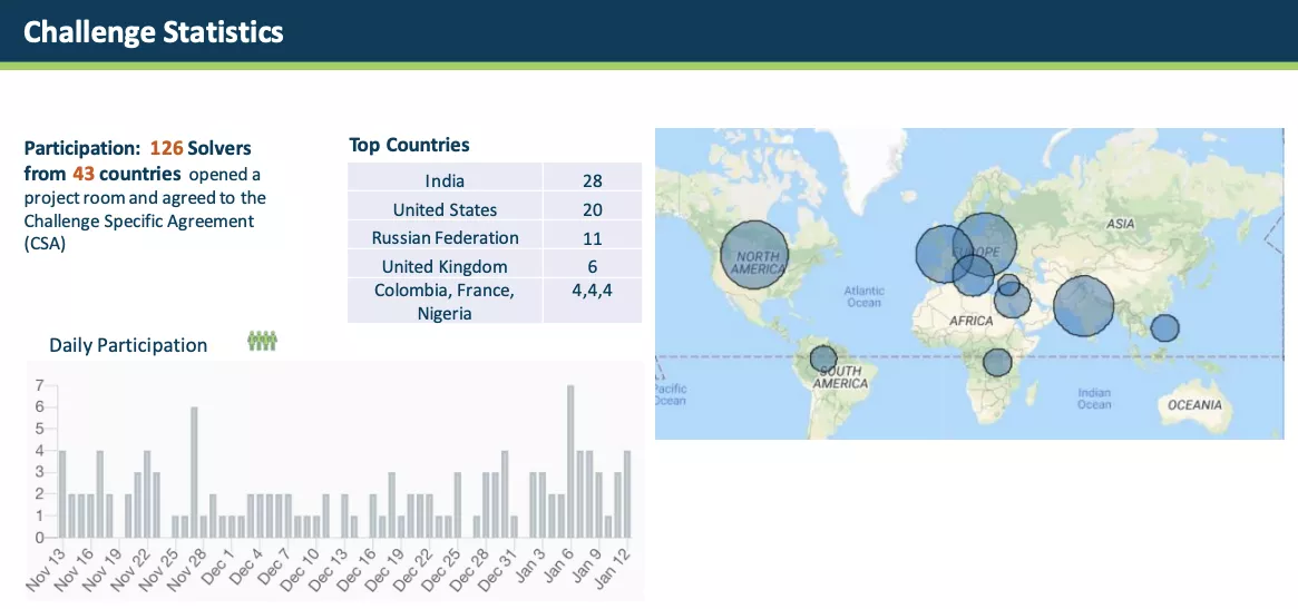
An image highlighting global participation in our Skin of the Earth Challenge. Image courtesy of Wazoku InnoCentive.
What’s really encouraging about this challenge is not only the opportunity to evaluate new potential data sources, but the scope of participation. Just how crowdsourced and wide-ranging this challenge is, has been a wonder to see, especially considering the international and language-varied nature of some of the submissions.
With over one hundred participants from five continents joining our quest to build out capabilities in Europe, we have selected two of the solvers as our challenge winners. Winning solutions include a detailed list of geography-specific soil and elevation data sources in the form of URLs.
What’s in it for the problem-solvers, you may ask? Regardless of how we end up utilizing the data within these two challenge solutions, the exploration merits award. InnoCentive challenges often include a financial award as compensation for the effort and innovative thinking of solvers. For Skin of the Earth, a US$ 10,000 award was offered, split between our two winners.
The solutions these two parties provided — researched and submitted within a two-month span — have the potential to be leveraged for training future agronomic models, and to be integrated into value-add capabilities for farmers across Europe and South Africa.
As for the solutions we have in hand now, we have some work ahead of us. Given the comprehensive nature of our combined solutions (plus a few language translation tasks), I am personally really excited to see what these resources have to offer our teams, and whether the data can be used to expand our platform and our models further.