Featured

Scale-Tec
View your live grain cart weights from Scale-Tec directly in your FieldView Cab app, giving you real-time visibility into every load with just a few simple steps.
View your live grain cart weights from Scale-Tec directly in your FieldView Cab app, giving you real-time visibility into every load with just a few simple steps.

Connect FieldView to Combyne for advanced crop marketing management: track deliveries, storage, profitability, contracts, and more.
tarjeta nueva de prueba

AcreConnect empowers farmers with a 360-degree view of their farms by integrating drone spraying data.
Seamlessly integrate to manage your inputs and save time.
Leverage data-driven insights and personalized methodologies, empowering farmers to maximize yields while minimizing environmental impact with Total Acre.

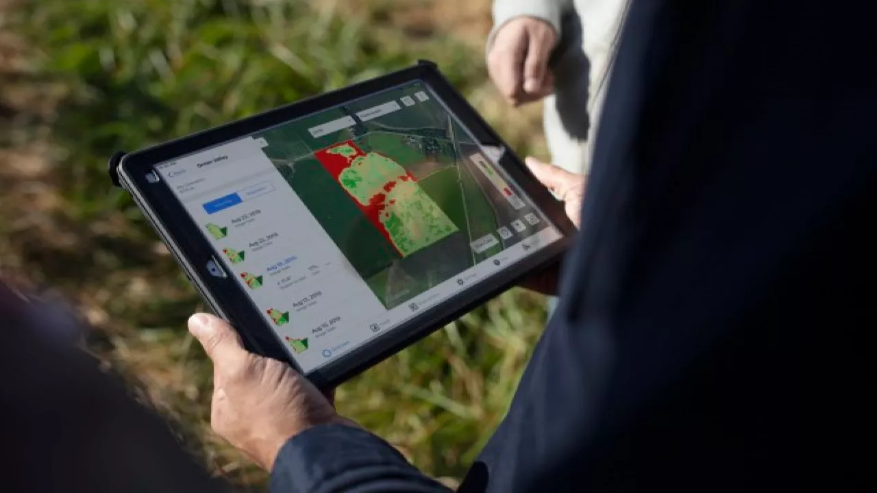
Make in-season corrections with real-time scouting insights.
Save time and simplify acreage reporting with MyAgData which formats your information to meet the reporting requirements of your FSA office and crop insurance companies.

Automate reporting for property and casualty insurance.

Seamlessly share your data with your trusted advisor to optimize crop management and boost yields with precision insights.
Leverage aerial and elevation drone data to streamline scouting, validate product trials, visualize data layers side by side, and generate variable rate prescriptions.
Save time and access crucial insights while easily maintaining inventory balances for crops and supplies, costs of production, and field level profitability.
Avoid duplicate data entry while making the best management decisions for your farm with real-time data sharing with your trusted advisor.

Sync data collected with Panorama seamlessly into Fieldview for agronomic insights and analysis.
Elevate your ability to analyze many precision agriculture display file types across your operation by connecting all of your machines, displays and devices.
Elevate the success rate of your field trials by accessing more efficiency and effectiveness to your field-level research and product development initiatives.

Tap into tailored advice and recommendations to best suit the growth needs of your unique farming operation.

Seamlessly share your data with your trusted advisor to optimize crop management and boost yields with precision insights.
Automatically populate activities in your Bushel Farm account to generate profit & loss insights, streamline logistics and workflows, and provide report to farm performance.

Use your data to earn income by adopting practices like cover crops and reduced tillage.
View costs and harvest revenues in one seamless interface with ProfitLayers.

Maximize your land value by connecting to buyers in growing environmental markets, for provable sustainability and carbon impact.

Make crop insurance faster, easier, and more accurate by seamlessly using your planting and harvest data for electronic reporting and claims.
Optimally manage your agronomy tasks and data by leveraging data sharing through the AgVance platform.
Generate in-season insights and post season analytics on your sugar beet operation.

Gain access to early, accurate and actionable crop cycle analytics such as crop performance, crop stress and plant nutrition.

Visualize and manage over 25 different soil layers to understand the variability of nutrients and textural-based properties of your field's soil.

Speed up your product development cycle as a seed producer by improving data acquisition, data analysis and data visualization.
Access real-time variable and average flat-rate nitrogen and irrigation management recommendations in minutes to maximize yield, minimize over-
Seamlessly share your data with your trusted advisor to optimize crop management and boost yields with precision insights.

Share your data with your trusted advisor to optimize crop management and boost yields with precision insights.
Simplify and automate your records instead of filling out and uploading forms to automatically pass average values to a sustainability calculator.

Seamlessly share your data with your trusted advisor to optimize crop management and boost yields with precision insights.

Gain in-depth analysis of a variety of scouting insights at critical growing season stages.
Predict the biggest threats in your operation such as pests and pathogens by measuring the biology of the soil before the season starts.
Achieve better profitabiity, predictability, safety and sustainability.

Sync CLAAS-generated yield and grain moisture maps seamlessly.

Sync field activities between your accounts and seamlessly export prescriptions.